24480 Fern Crescent, Maple Ridge, BC V4R 2S1, Canada
Get directions
Phone +1 604-466-8325
Visit website
Despite being one of BC’s biggest provincial parks, Golden Ears Provincial Park is only 11 kilometers away from Maple Ridge. Loved for its recreational offerings, the park’s trails are popular among hikers and horse riders, while Alouette Lake serves as a favorite spot for water sports and swimming. With three campgrounds and mountainous backcountry, there’s something for every adventurous traveler in this park.
Background
Originally the traditional hunting and fishing grounds for the Douglas-Lillooet (Interior Salish) and Katzie (Coast Salish) First Nations peoples, the Alouette Valley’s forests were also site to BC’s largest railroad logging operation in the 1920s until a devastating fire ravaged the area in 1931. In 1967, the 62,540-hectare area (about 154,500 acres) was designated as a Provincial Park. Some believe it derives its name from the two peaks that resemble ears, while other theories suggest it was first named Golden Eyries, in honor of the eagles residing there.
What to Do and See There
Hikers can choose from a range of trails varying from short strolls to intensive climbs, and horse riders can explore over 20 kilometers of trails on horseback. The Spirea Universal Access Trail is wheelchair accessible, making it inclusive for all.
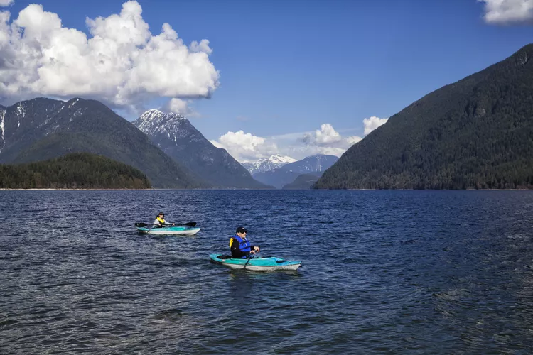
Day visitors can enjoy the south beach part of Alouette Lake, which is perfect for sandy beach activities and swimming. Moreover, canoe or kayak rentals are available, along with opportunities for water skiing and windsurfing, thanks to the vehicle-accessible beach.
Interpretive tours are offered, and if you possess the appropriate license, there is freshwater fishing available at Alouette Lake, Mike Lake, and Gold Creek.
:max_bytes(150000):strip_icc():format(webp)/GettyImages-638195976-5b992fae46e0fb0050531ef9.jpg)
Best Hikes
Home to numerous trails, Golden Ears is a popular destination for beginner, intermediate, and advanced hikers alike.
- From the Gold Creek campground parking lot, there is a fairly even 2.8-kilometer Lower Falls Trail to Gold Creek’s Lower Falls that takes around an hour each way, with a river beach halfway up the trail serving as an ideal picnic spot. Dogs are allowed, but it’s closed to bikers and horse riders.
- The Mike Lake Trail is designed for horse riders and hikers alike, taking about two hours each way (4.2 kilometers) and climbing 100 meters.
- The Incline Trail follows the historic route that was once used by loggers to transport massive logs down to Mike Lake (1.2 kilometers, about an hour each way).
- Experienced hikers can take on the strenuous Alouette Mountain Hiking Trail from Mike Lake for breathtaking views from Alouette Mountain.
- During the wet season, the Viewpoint Trail showcases numerous waterfalls along the way (1.5 kilometers, three hours roundtrip).
- For hardcore hikers, the Golden Ears Trail leads to Alder Flats, where a steep ascent up an old logging road takes you to Panorama Ridge, allowing you to wilderness camp overnight (12 kilometers round-trip, seven hours, 1.5 kilometers in elevation).
Camping/Facilities
Camping opportunities abound, with wilderness camping permitted at Alder Flats on the West Canyon Trail and at Panorama Ridge on the Golden Ears Trail. Pre-booking is usually essential, involving a 5- to 9-kilometer hike.
For boat travelers, basic marine campsites are situated on Alouette Lake at Moyer Creek, The Narrows, or Alouette River, and at Pitt Lake, specifically Raven Creek and North and South Osprey Creek. Only accessible by boat, these rustic sites include tent pads and a pit toilet; however, campfires are not permitted. Hot showers are provided at the Alouette and Gold Creek campgrounds, though there are no showers available at North Beach campground. Alouette and North Beach campgrounds are open (and can be reserved) from June to September, whereas Gold Creek operates from May to October and is reservable during summer.
How to Get There
Located in the Coast Mountains, the park is reachable via Highway 7 or Dewdney Trunk Road through Maple Ridge. If you’re heading west, turn right onto 232nd, and if you’re heading east, turn left onto 232nd. Then, turn right onto Fern Crescent and continue into the park.


