Summary
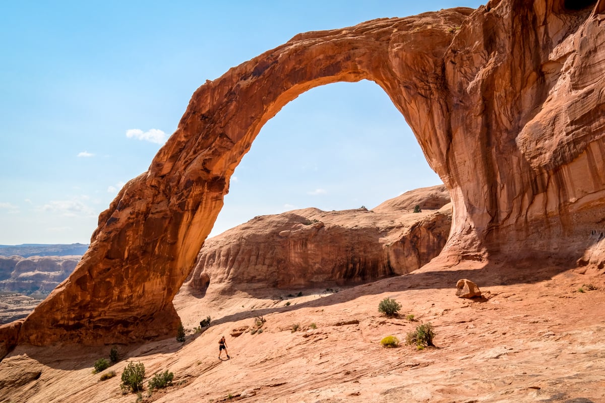
The Corona Arch trail is a wonderful hike located near Moab, Utah, featuring three distinct natural sandstone arches. This relatively easy trail is suitable for all ages, offering views of Pinto Arch (optional), Bowtie Arch, and culminating at the spectacular 140-foot-wide Corona Arch, which you can walk through. This guide will detail everything you need to know before embarking on the Corona Arch hike.
Quick Facts
- Distance: 2.5 miles (4 km) round trip
- Elevation Gain: 500 feet (150 m)
- Duration: 1 – 3 hours round trip
- Difficulty: Easy / Moderate
*These stats are specifically for the hike to Corona Arch, excluding Pinto Arch and Bowtie Arch.
Corona Arch Trail: What To Expect
The Corona Arch hike features a canyon trail leading you to two main arches (Corona and Bowtie) along with an optional visit to Pinto Arch if time permits. This hike is largely manageable; however, the mid-day heat and a short section requiring the use of a small ladder may present slight challenges.
Due to its proximity to Moab, the Corona Arch trail is popular. Therefore, visiting during weekdays or in the morning is advisable to enjoy a quieter experience.

• Trail Beginning
The hike commences with a brief uphill trek, leading you across some old Potash Railroad tracks still in use. While the trail may seem primitive, the presence of rock cairns and green paint marks on the slickrock ensures you remain oriented.
Thanks to these recent green paint marks, navigating the trail has become quite straightforward.


• Pinto Arch
Approximately halfway into the hike, an optional detour allows you to explore Pinto Arch, a pothole arch located at the top of the canyon. Climbing to see Pinto Arch may not be necessary, especially since it closely resembles Bowtie Arch, which you will encounter on your way to Corona Arch.
The advantage of seeing Pinto Arch is the opportunity to stand beneath it for a closer look, which isn’t as feasible at Bowtie Arch.
If you choose to visit Pinto Arch, follow the signs and the green paint marks for an additional 0.6 miles (one way) with an elevation gain of about 340 feet.


• Stairway / Ladder Section
The final challenge of the Corona Arch hike involves a steep slickrock stairway and a ladder climb. While dogs and children can navigate this section with assistance, the primitive stairway requires some support from the cable.
The ladder, standing at about 6 feet tall, may seem intimidating. However, while the last step is significant, it is not as difficult as it appears. At this point, Bowtie Arch and Corona Arch become visible in the distance, and simply continue on the slickrock shelf to reach the arches.


• Bowtie Arch
As you approach Corona Arch, Bowtie Arch will be visible to your left. No extra hiking is required to see Bowtie Arch, as it lies merely 150 yards away from Corona Arch, giving you two stunning arches to admire.
The colors and texture of Bowtie Arch are impressive; it is a pothole arch formed when water filled a pothole above the canyon, gradually eroding into a cave below.


• Corona Arch
Your ultimate stop is the magnificent Corona Arch! This natural sandstone wonder measures 140 feet wide and 105 feet tall. Visitors can walk through the arch to access the area on the other side, where an intriguing stone face can be spotted in the canyon wall.
Although Corona Arch is not part of Arches National Park, it undoubtedly ranks among the finest arches in the Moab area!


Corona Arch Trailhead: How To Get There
Located just outside Moab and Arches National Park in eastern Utah, the Corona Arch trailhead is easily accessible via Potash Road. Along this road, you can find fascinating prehistoric dinosaur tracks and other intriguing sights.
Here are the GPS coordinates: 38.57806231735949, -109.63267036129403
Furthermore, you can utilize the Google map below to navigate directly to the parking area, which is about a 20-minute drive from Moab.
Trailhead Conditions
The route to the Corona Arch trailhead consists entirely of paved roads, eliminating the need for high clearance vehicles. Upon arrival, you’ll find a vault toilet, information signs, and a trail map.
As a reminder, keep the trail clean, respect other hikers, and leave no trace.


Best Time To Visit
The Corona Arch hike is captivating throughout the day; therefore, when you visit is flexible. However, be prepared for higher temperatures and larger crowds during mid-day.
The photographs featured on this page were taken in the early afternoon, around 2 PM, allowing us to capture images without excessive sun glare.
In mid-September, early mornings or late afternoons may restrict your ability to photograph the arch from both sides due to sun glare. For optimal results, visit during sunrise or early morning hours to photograph the arch from the back.
Conversely, for visits at sunset or in the late afternoon, front-facing photographs are generally more rewarding.


Corona Arch Swing
Between 2011 and 2012, viral YouTube videos showcased individuals rope swinging off the top of Corona Arch, coining it as ‘the world’s largest rope swing.’ Unfortunately, a tragic accident in 2013 led to the death of a Utah man when his rope was too long.
In 2015, the Bureau of Land Management banned this activity. Initially deemed temporary, the ban has remained in place since then.
Below is a link to one of the previously viral rope swing videos, which certainly looked exhilarating.
Best Utah Tours
More Utah Travel Guides
Thank you for your interest! This guide to the Corona and Bowtie Arch trail near Moab, Utah, aims to provide a comprehensive overview of this stunning hike.


