Introduction to Bash Bish Falls
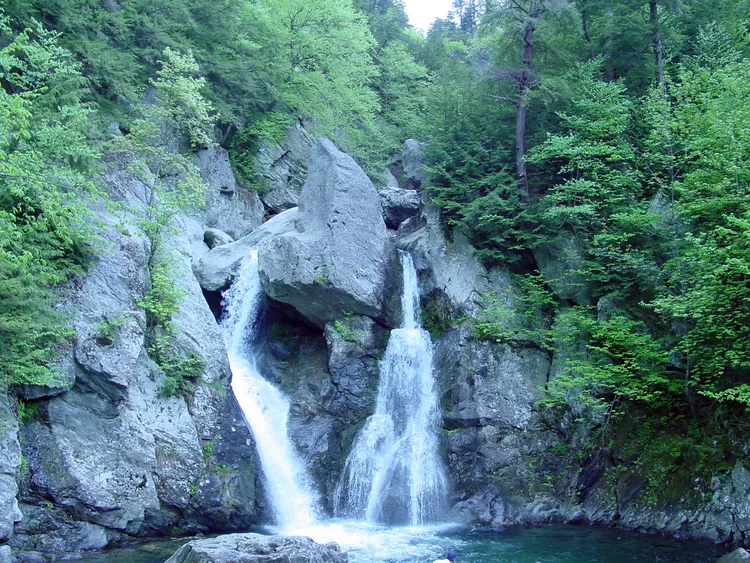
It’s not Niagara Falls, mind you, but Bash Bish Falls, tucked away in the southwest corner of Massachusetts near the state’s borders with Connecticut and New York, is the state’s highest waterfall. In fact, you get two waterfalls for the price of one when you visit Bash Bish State Park, and best of all, the experience is free!
Bash Bish Falls State Park is located within the Mount Washington State Forest, a 4,169-acre forest preserve managed by the Massachusetts Department of Energy and Environmental Affairs. This stunning state forest boasts 30 miles of hiking trails, and a limited number of wilderness camping sites are also available free of charge. However, most visitors have one goal in mind–to catch a glimpse of the twin falls that drop in a dramatic, 80-foot “V” over steep boulders, contributing to the warming spray of foam in the serene pool below.
Picturesque Bash Bish Falls has been a cherished tourist destination in the Berkshires and a favorite subject of artists and photographers since the mid-19th century. Upon your arrival, you’ll feel as if you’ve uncovered a secret woodland cascade, despite the likelihood of encountering many other waterfall enthusiasts unless you visit early or late in the day or during the winter months.
There are two access points for viewing Bash Bish Falls. Following signs from Route 41 in Egremont, Massachusetts, you’ll first arrive at the upper parking lot on the left, from which the waterfalls are about a 15-minute downhill hike. Remember–you’ll have to hike back uphill when you’ve had your fill of the cascades’ whooshing roar. The hike is moderate but may be slippery in parts after significant rain. An easier point of access is the lower parking lot, which is the second area you’ll reach on the left.
What You Need to Know About Bash Bish Falls
Directions: Bash Bish Falls State Park is accessible from Route 41 in Egremont, Massachusetts. From the Massachusetts Turnpike (I-90), take exit 2 for Route 102 West and continue to Route 7 South. Route 7 South merges with Route 23 West, and where they diverge, continue on Route 23 West to Route 41 South. It’s just a short distance to the entrance road for the Mount Washington State Forest and Bash Bish State Park–watch for signs on the right. From Connecticut, follow Route 44 West to Salisbury, where you can pick up Route 41 North to the park entrance on the left, just before the junction with Route 23. From New York, follow Route 44 East to Salisbury, then follow the Connecticut directions or Route 23 East to Route 41 South.
Admission Fee: Free.
Hours: Dawn until a half-hour after sunset.
Bring Along: Sturdy hiking shoes or boots, bug spray, sunscreen, and a camera.
Camping: There are 15 wilderness campsites available in the Mount Washington State Forest, located approximately a mile and a half from the State Forest headquarters on East Street. There is no charge for use of the campsites, and access operates on a first-come, first-served basis. The maximum camping party size is five people.
Hotels Near Bash Bish Falls: Compare rates and reviews for Egremont-area hotels with TripAdvisor.
