Summary
Annular Eclipse Across the Americas
One of the rarest types of solar eclipses, the annular eclipse, also known as a “Ring of Fire”, will traverse the Americas on Saturday, creating a remarkable spectacle for observers in its path.
Finding the Perfect Viewing Location
Those searching for the ideal time and place to view the eclipse will be pleased to know that The Planetary Society, a non-profit space organization led by Bill Nye, has developed a Total Solar Eclipse Map. This resource will help you locate prime viewing spots and detail the timing of the eclipse.
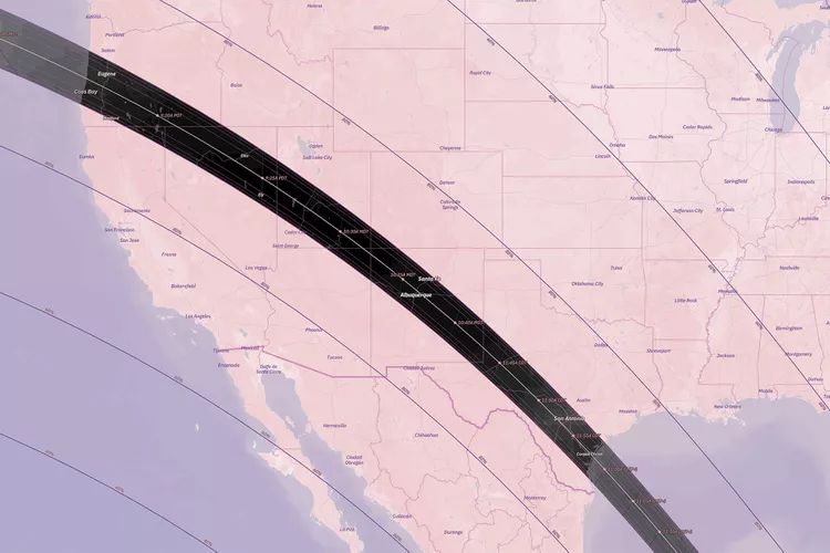
The map provides a comprehensive overview of North and South America. It indicates the annularity regions where the moon will completely cover the sun, stretching from Oregon to northern Brazil.
:max_bytes(150000):strip_icc():format(webp)/TAL-full-path-annular-eclipse-map-SLRECLIPSEMAP1023-6ed7e32bf69d40ad86a65e879901d82c.jpg)
What to Expect During the Eclipse
By clicking on major cities within the annularity region, the map reveals accurate timings for the event (down to the second), the duration, average cloud cover, and sun altitude. For example, in Eugene, Oregon, annularity will be observable from 9:16:57 a.m. to 9:20:52 a.m. local time, lasting approximately three minutes and 55 seconds. The expected average cloud coverage is around 45 percent, and the sun’s altitude will be at 18 degrees. Various phenomena, such as the partial sun, crescent shadows, and the “Ring of Fire,” will also be visible during this period.
Similarly, in Corpus Christi, Texas, the same seven phenomena will be visible for five minutes and two seconds, from 11:55:30 a.m. to 12:00:52 p.m., with an average 50 percent cloud cover and a sun altitude of 49 degrees.
Looking Ahead: Future Eclipse Events
Beyond the annular eclipse, the map also anticipates the total solar eclipse scheduled for April 8, 2024. This includes viewing expectations, vocabulary lists, and safety tips to enhance your experience of these rare celestial events. For avid astronomy fans, special eclipse glasses featuring Bill Nye’s image are also available for those wanting to make the most of these spectacular experiences.


