Summary
Chiapas is Mexico’s southernmost state and, although it is one of the poorest, it offers great biodiversity, remarkable landscapes, and rich cultural expressions. In Chiapas, you will find scenic colonial towns, important archaeological sites, tropical rainforests, lakes, high mountains, and an active volcano, as well as a significant Maya indigenous population.
Quick Facts about Chiapas
- Capital: Tuxtla Gutiérrez
- Area: 45,810 miles² (73,724 km²), 3.8% of the national territory
- Population: 4.3 million
- Topography: Volcanic mountain ranges, tropical rainforest, and coastal lowlands. The highest elevation is Tacaná volcano at 13,484 feet (4,110 m) above sea level in the Sierra Madre de Chiapas.
- Climate: Subtropical with average temperatures between 68 and 84°F (20 to 29°C) in the lowlands; cool to warm with higher rainfall in summer in mountainous areas.
- Flora: Mangroves, pastures, rainforests, and pine trees in the mountains.
- Fauna: Porcupines, agoutis, jaguars, ocelots, monkeys, anteaters, crocodiles, turtles, and a wide variety of birds.
- Major Festivals: Fiesta de Enero (January Festival) in Chiapa de Corzo from January 8 to 23.
- Archaeological Sites: Palenque, Toniná, Yaxchilán, Bonampak.
Tuxtla Gutierrez
The capital of Chiapas state, Tuxtla Gutierrez has a population of approximately half a million residents. It is a vibrant modern city containing a reputable zoo and an excellent archaeological museum. Moreover, the nearby Cañon del Sumidero (Sumidero Canyon) is a must-see. This breathtaking 25-mile-long river canyon features cliffs soaring over 3,000 feet and abundant wildlife, best explored via a two-and-a-half-hour boat trip from Chiapa de Corzo or Embarcadero Cahuare.
San Cristobal de Las Casas
San Cristobal, one of Chiapas’ most charming cities, was founded in 1528. This colonial town, with its narrow streets and colorful one-story houses adorned with tiled roofs, provides a lively atmosphere. Visitors can experience a journey back in time through its many churches and museums, complemented by a contemporary bohemian ambiance featuring art galleries, bars, and sophisticated restaurants catering to international travelers and expats. Additionally, locally dressed indigenous people sell handicrafts in the market, enhancing the city’s vibrant culture.
Palenque Town and Archaeological Site
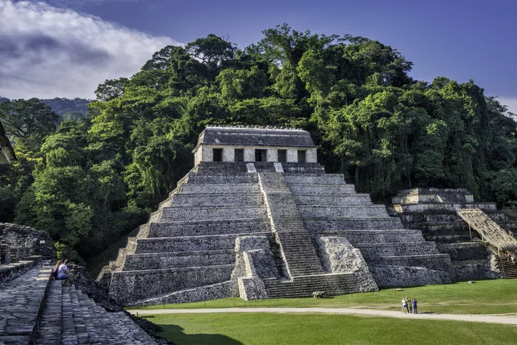
The small town of Palenque serves as a bustling hub for excursions to one of Mesoamerica’s most important archaeological sites, surrounded by lush rainforest. Originally known as La Kam Ha (the place of much water), this site was renamed Palenque by the Spanish. The on-site museum offers valuable insights into the site and Maya culture, making it a recommended stop after exploring the ruins. While traveling from San Cristobal de las Casas to Palenque, do not miss the stunning waterfalls of Misol-Ha and Agua Azul.
More Archaeological Sites
For those eager to delve deeper into Mesoamerican history, there are several remarkable archaeological sites in Chiapas accessible from Palenque. These include Toniná and Bonampak, known for their unique wall paintings, as well as Yaxchilán, located along the banks of the Rio Usumacinta, Mexico’s largest river. The latter two sites are nestled within the Selva Lacandona, part of the Montes Azules Biosphere Reserve.
Chiapas Adventure Tourism
Traveling southwest across the state allows you to follow the Ruta del Café (Coffee Route), hike up Tacaná Volcano, or relax on the Pacific coast, which features predominantly grey-black beaches at Puerto Arista, Boca del Cielo, Riberas de la Costa Azul, or Barra de Zacapulco. Additionally, Sima de las Cotorras is a remarkable sinkhole home to thousands of green parakeets.
Revolutionary Activity and Safety Concerns
The Zapatista (EZLN) uprising occurred in Chiapas during the 1990s, beginning on January 1, 1993, when NAFTA took effect. Although the EZLN is still active and maintains a presence in some areas of Chiapas, conditions are relatively peaceful, and there are no significant threats to tourists. However, travelers are advised to respect any roadblocks encountered in rural regions.
How to Get There
International airports are located in Tuxtla Gutierrez (TGZ) and Tapachula, close to the border with Guatemala.


