Summary
Dramatic Overlook is One of Maine’s Most Scenic Spots
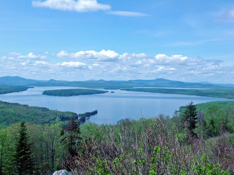
Height of Land is one of the most picturesque places in Maine and perhaps all of New England. Located in the western part of the state, this scenic overlook on Route 17 near Rangeley, Maine, will take your breath away.
This beautiful location shines in all four seasons: summer, fall, winter, and spring. The panoramic images of the calm, pristine Mooselookmeguntic Lake framed by blue skies and New Hampshire’s White Mountains capture the essence of this scenic spot.
Also on the Way to Rangeley:
- Pan for Gold in Maine’s Coos Canyon
- Smalls Falls
Height of Land is stunning and considered one of the most photogenic locations in New England. It is situated just south of Rangeley, Maine, at the point where the Appalachian Trail crosses Route 17. For easy navigation, set your GPS to: Maine 17, Roxbury, ME 04275.
Lake and Mountains
:max_bytes(150000):strip_icc():format(webp)/Mooselookmeguntic-Lake-lg-56fbf9855f9b5829868e5a3b.jpg)
The lovely scene visible from Maine’s Height of Land showcases Mooselookmeguntic Lake in a stunning mountain setting. Its breathtaking beauty emphasizes the close proximity of New England’s highest peaks to western Maine.
Drive-By Beauty
:max_bytes(150000):strip_icc():format(webp)/height-of-land-maine-lg-56fbfb193df78c7841b197fc.jpg)
Height of Land is a stunning spot easily reached by car. Although there are no signs, simply look west while driving north on Maine’s State Route 17 toward Rangeley, and you’ll find this breathtaking overlook.
Mooselookmeguntic Up Close
:max_bytes(150000):strip_icc():format(webp)/Mooselookmeguntic-Lake-2-lg-56fbfbf73df78c7841b1a772.jpg)
Mooselookmeguntic Lake dominates the view from Height of Land. This pristine, 16,300-acre lake is Maine’s second-largest body of water, and its name originates from a native Abanaki word meaning “portage to the moose feeding place.”
Mirroring the Sky
:max_bytes(150000):strip_icc():format(webp)/height-of-land-overlook-lg-56fc00323df78c7841b1d112.jpg)
Photographers appreciate the way clear, calm Mooselookmeguntic Lake mirrors the mountains and sky, creating picturesque scenes. Anglers also enjoy the lake, as it abounds with salmon, trout, and various other fish species.
Toothaker Island
:max_bytes(150000):strip_icc():format(webp)/toothaker-island-height-of-land-lg-56fc00c93df78c7841b1d259.jpg)
The small, narrow island situated within Mooselookmeguntic Lake is known as Toothaker Island. This charming island adds additional visual interest to the Height of Land scenic vista, and wilderness camping on Toothaker Island is a possibility, providing another unique experience.
