Summary
- Introduction to the Iron Gates of the Danube River
- Iron Gate of the Danube River between Serbia and Romania
- Dacian Chief Decebalus Carved into the Iron Gates
- High Cliffs Line the Iron Gate of the Danube River
- The Mraconia Monastery on the Iron Gates of the Danube River
- Cross on Cliff Overlooking the Danube River
- Iron Gate of the Danube River between Romania and Serbia
- Cave in the Rock Wall of the Iron Gates of the Danube River
Iron Gates of the Danube River
The Iron Gates of the Danube River originally consisted of four narrow gorges and three wide basins stretching over several miles of the river, which forms a natural border between Romania and Serbia. The term “Iron Gate” was first used by The Times of London in 1853. While some consider the entire 83-mile stretch of the river to be the Iron Gates, most define it specifically as the section containing the four narrow gorges.
In the 1960s, the government constructed a substantial lock and dam to help control the river’s speed and enhance navigation safety. Before the Danube River was dammed, commercial vessels transporting goods feared navigating the rapids of the narrow Iron Gates section. Subsequently, the completion of the dam project calmed the river, resulting in a water level increase of 130 feet compared to before the dam and power station were established. The two locks, positioned more than 50 miles apart, anchor each end of the Iron Gates, and the dam’s impact can be felt for over 100 miles; over 23,000 residents along the river had to be resettled following its completion.
Danube River cruises in Eastern Europe travel through the Iron Gates during the daytime, offering breathtaking scenery, although it is not as dramatic as it was over 50 years ago. Most river cruise travelers regard the Iron Gates area and the Wachau Valley in Austria as the most scenic portions of the Danube River.
Eastern European Danube River cruises typically operate between Budapest and Bucharest or the Black Sea. Travelers wishing to traverse Europe from the Black Sea to the North Sea at Amsterdam can merge an Eastern European Danube River cruise with a “Grand European” river cruise that spans Budapest and Amsterdam.
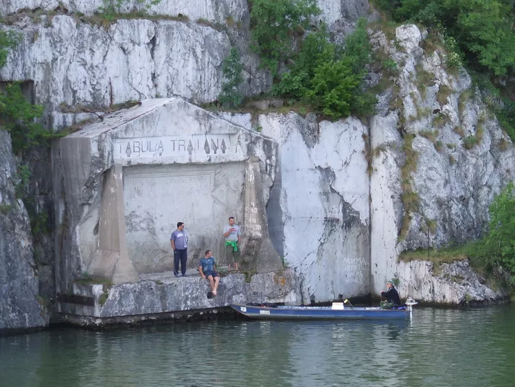
Iron Gate of the Danube River between Serbia and Romania
The Tabula Traiana marker, established by the Roman emperor Trajan over 2000 years ago, is visible on the left side. Located on the Serbian bank of the Danube, it was relocated to its current position in 1972 when the dam and hydroelectric station caused water levels to rise.
Dacian Chief Decebalus Carved into the Iron Gates
This enormous face carved into the Romanian bank of the Danube River honors the Romanian hero Decebalus, who battled the Romans valiantly.
High Cliffs Line the Iron Gate of the Danube River
The towering cliffs lining this wider section of the eastern Danube River render it one of the most picturesque locations in the region. Once vessels pass into the narrower part of the river, the width can reduce to mere 500 feet.
The Mraconia Monastery on the Iron Gates of the Danube River
A monastery was originally constructed at this site in the 14th or 15th century, though the exact date is uncertain. The building, however, was destroyed during battles in the 17th century. Reconstruction efforts were suspended when rising waters in the 1960s submerged the ruins completely. In 1993, a new stone Mraconia Monastery was built above the submerged site.
Cross on Cliff Overlooking the Danube River
This cross is notably larger than it appears in the image, as the cliffs overlooking the Danube River reach impressive heights of up to 1000 feet.
Iron Gate of the Danube River between Romania and Serbia
Narrow gorges, like this one on the eastern Danube River, were once filled with rapids prior to the dam installation. The final gorge of the Iron Gates creates a natural boundary between the Carpathian and Balkan mountains.
Cave in the Rock Wall of the Iron Gates of the Danube River
Numerous caves dot the rock walls of the Iron Gates of the Danube River, serving as a natural separation between Romania and Serbia. The most prominent cave, Ponicova, is near Dubova Town, also referred to as Water Mouth Cave and Bat’s Cave.


