Overview of Tioga Pass
Tioga Pass serves as a passageway rather than a destination in itself. Standing at an impressive 9,941 feet above sea level, it connects Yosemite Valley with eastern California. The journey across Tioga Pass is considered one of the most picturesque drives in the Sierra Nevada region, making it a popular route for travelers seeking stunning landscapes.
Best Scenic Stops
The nearly 80-mile drive from Yosemite Valley to Lee Vining (on US Hwy 395) typically takes at least two hours. However, with various breathtaking spots along the way, you may be tempted to take your time. Here are some must-see scenic points as you drive east from Yosemite Valley:
- Olmsted Point: A key lookout offering spectacular views of the northern side of Half Dome—perfect for photography enthusiasts.
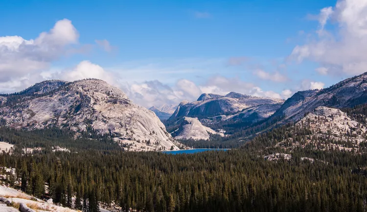
- Tenaya Lake: An irresistible spot for a selfie in front of a crystal-clear lake, framed by rugged granite cliffs.
- Tuolumne Meadows: Known for its unique geography, it offers areas prone to seasonal flooding and vibrant wildflower blooms in spring.
- Tioga Lake: Though smaller than Tenaya Lake, it is conveniently located near the roadside, boasting great views and opportunities for trout fishing.
- Ellery Lake: Located just outside the park boundary, it features a small, primitive campground operated by the National Forest Service.
- Tioga Pass Resort: A rustic lodging option famed for its serene location—often described as a hidden gem.
When is it Open?
Tioga Pass is one of the few routes traversing the Sierra Nevada. However, it’s important to note that the road is frequently subject to seasonal closures due to snow. Typically, Tioga Pass closes after the first significant snowfall of the winter, and it reopens following sufficient thawing that allows for road clearing.
In the early snow season, there may still be opportunities to drive over Tioga Pass, but it’s vital to be aware of California’s snow chain regulations. The exact dates for opening and closing can vary each year depending on weather conditions. Generally, Tioga Pass is open to vehicles from late May or early June through mid-November. To get a better idea of operational dates, consider checking historical records of Tioga Pass openings and closings by year.
If you plan to travel during potential closures, having a contingency plan is essential. If Tioga Pass is closed, nearby mountain passes are likely to be closed as well. For access to the eastern side of the mountains, consider taking a detour north through Lake Tahoe via US Hwy 50 or I-80. Alternatively, if your journey takes you south (to Mt. Whitney, Lone Pine, or Manzanar), you could navigate through US Hwy 99 to Bakersfield and then head east on CA Hwy 58 through Mojave, connecting to US Hwy 395. Whatever alternate route you choose, it’s crucial to check current road conditions to ensure that your chosen highways are open for travel.
Accessing Tioga Pass
The only way to reach Tioga Pass from either direction is via CA Hwy 120, which is the highest automobile pass in the Sierra Nevada. Ensure your vehicle is adequately prepared with either a full tank of gas or a fully charged battery for the journey.
Since CA Hwy 120 cuts through Yosemite National Park, an admission fee is required for access. If you are only looking to traverse the mountains without exploring the park, consider using Sonora Pass on CA Hwy 108 as an alternative route.


